Flight Planning with SkyDemon
We created SkyDemon to make flight planning as fun as it can be, by removing as many of the tedious parts as possible. Planning a flight in SkyDemon is as simple as touching consecutive waypoints on the map and watching all the best NOTAM, weather, charting and other aeronautical briefing information appear at your fingertips.
Our customers tell us that SkyDemon gives them the confidence to fly further and to more interesting places. Read on to learn more about our best flight-planning features, or start a free trial to try it for yourself.
The Clearest Charts
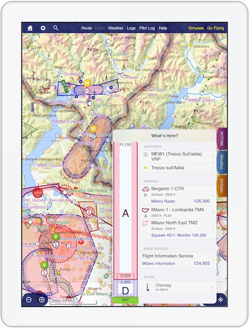
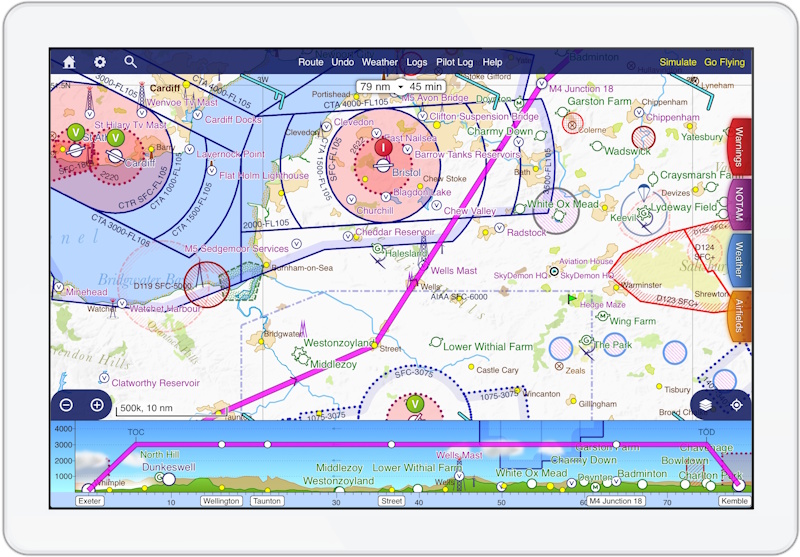
Amazing charts strike the right balance between showing you the information you need at a glance, and keeping the map clear enough for you to quickly find what you're looking for. Our bespoke charts typically contain way more detail than the paper charts they replaced, but don't show it all at once. Some might appear when you zoom in, and some is accessible when you place a finger on the screen to reveal the What's Here menu, featuring an airspace stack and more information about everything under your finger.
Unlike traditional charts, ours are updated every 28 days and have a consistent style no matter where in the world you're looking. The text on our charts always stays the right way up, even if you rotate the chart. They are created from the same raw aeronautical data that powers other SkyDemon features, and because of this, you can customise them for the type of flying you do and your own visual preferences. Airspace that starts way above the altitudes at which you normally fly is hidden unless you plan a flight that high.
Alongside the regular cycle of chart updates, temporary restrictions are published via NOTAM or AIP SUP literally every few minutes, and these are integrated seamlessly into our charts alongside more permanent data. No other service is as good at depicting temporary hazards and restrictions as SkyDemon.
Best of all, because our enroute charts are created and owned by us, they are included as a standard part of every subscription.
Aviation Weather
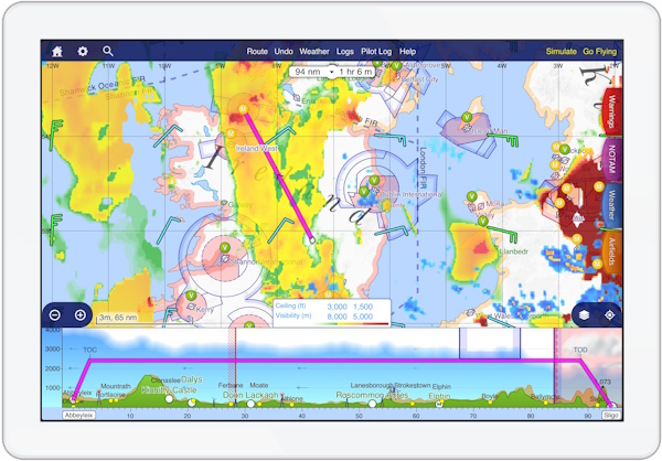
As you explore our charts and plan your flight, you will see the latest TAF and METAR bulletins appear on the map, showing the suitability of the weather for VFR flight. You tell SkyDemon what ceiling and visibility you are comfortable flying in, and we colour-code the indicators accordingly. The virtual radar view of your planned flight decodes these bulletins so individual cloud layers and precipitation can be seen around the publishing airfield.
Our unique Flyable Conditions feature builds on this personalised forecast depiction to bring you a high-resolution map overlay showing exactly which areas are flyable, marginal, or not flyable. This hugely-powerful feature also includes lowest-cloud-top data so you can visualise not only the ceiling but the thickness of the cloud in virtual radar, and plan to fly above it. Delivered as a nowcast, this data extends up to two hours into the future, and several hours into the past. Using our animation tools you can therefore form a superb picture of how the conditions are changing over the day.
Wind forecasts, both aloft and at the surface, are integral to the calculations SkyDemon performs to give you the correct headings to fly, and to accurately model your fuel consumption. You can use this wind data to find the best altitude at which to fly, which for a lengthy trip can save time and fuel. GAFOR forecasts are also integrated across Europe for the countries that publish them, so you can see at a glance how the weather through mountainous terrain or in certain areas is predicted to change over time.
Briefing Information

As well as the clever depictions on the chart, all the TAF, METAR and NOTAM bulletins relevant to your planned flight are of course available for reading. We decode weather bulletins so you don't need to remember all the jargon, and NOTAMs are categorised so the less relevant are pushed to the bottom of the page. If you think a NOTAM is so absurd that you never want to see it again, you can hide it.
Airfields in SkyDemon have their own documents and charts available at the touch of a button, from airfield diagrams and textual information to instrument approach charts. Most airfield charts are georeferenced, meaning you can embed them inside the main SkyDemon chart and see your aircraft on them. Tens of thousands of European pilots contribute data on airfields, from ratings and fuel prices to thoughtful notes for other pilots, and these can be really useful when it comes to discovering new destinations. We license national AIPs and make these available as a standard part of every subscription, and some third-party products are also available as optional extras.
As you plan, SkyDemon models your flight and calculates your minimum safe altitudes for each leg, the headings to fly, your fuel consumption and any enroute hazards. It does this taking into account the performance characteristics of your selected aircraft and the weather conditions for the time of the flight. It will prepare a full weight and balance schedule based on your aircraft profile and the fuel, passenger and baggage weights entered. For an international flight, it will produce an ICAO flightplan with almost every field filled in automatically, and this can be filed directly to ATC from the app.