Navigating with SkyDemon
We created SkyDemon to make VFR flying as fun as it should be, by removing all worries about navigation, warning you about any upcoming hazards, and giving you the best briefing data whenever you need it. When you've got SkyDemon looking after you, you'll spend less time looking at maps and paperwork and more time looking out of the window enjoying the flight.
Our customers tell us that SkyDemon has boosted their confidence when flying in increasingly complicated airspace, and helped them to fly to new and interesting places. Read on to learn more about our best navigation features, or start a free trial to try it for yourself.
The Clearest Charts
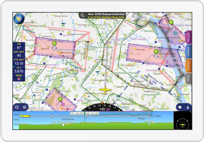
During flight you get the same ultra-clear charts as you used while planning, which look fantastic whether you prefer north up or track up. They even include the ground features of most airfields in Europe, so before takeoff and after landing you'll see taxiways, holds, buildings and more. On appoach you'll see circuit diagrams and other traffic guidance where available. Many airfields have georeferenced charts from the national AIP or third-party providers, and you can choose to overlay these inside the main map.
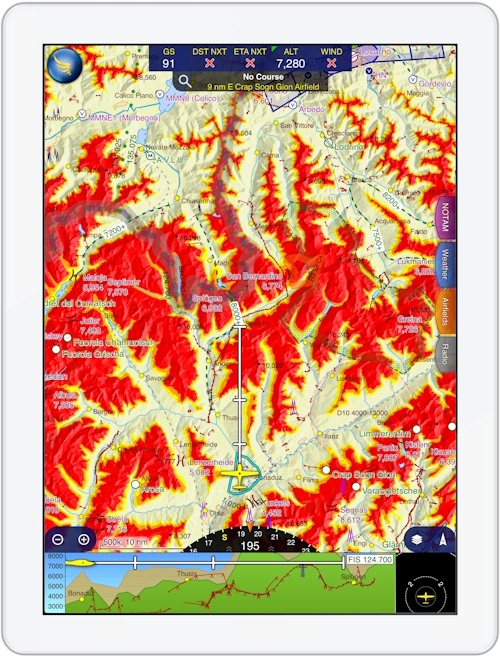
If you fly in the mountains, you can colour the terrain around you so that you can tell at a glance where is safe to fly at your current altitude. This can be a life-saving feature if the weather closes in unexpectedly, or you can even turn it on while planning to plot the safest way through the terrain ahead of time. You will also see a blue ring around your aircraft showing where you can glide to in the event of an engine failure, which can provide reassurance while over water or hostile territory.
As when planning, you can tap the chart anywhere to get more information about what's at the position underneath your finger in the What's Here menu, including an instant reading of its distance, bearing and flight time from your current location. You can also bring up a ruler on top of the map, to quickly measure the distance between any two points.
Many people use a traffic receiver device with SkyDemon. When using one of these, you will also see other aircraft on the map, with symbols to match their airframe type.
Enroute
The instruments in SkyDemon are designed to be simple and show just what you need. Use the direction indicator at the bottom of the map to keep aiming towards your next waypoint, and use the distance and time instruments to monitor when you'll get there. A wind instrument shows what the wind is doing outside, and a permanent position report at the top of the screen makes it easy to give ATC a plain-English description of your location if they ask.
Virtual radar is the instrument at the bottom of the screen showing your trajectory ahead relative to terrain, airspace, obstacles and other features. It includes your planned route so you can clearly see when it's time to begin a long climb or descent.
If you're flying towards controlled or dangerous airspace, you'll see a warning including advice on who to call to gain penetration where available. Warnings are also shown if you fly towards terrain, ground-based obstacles, temporary restrictions introduced by NOTAM or AIP SUP, or other types of airspace. As well as showing onscreen and making a noise, speech is also produced for some types of warnings, telling you about other aircraft flying close to you, or when you taxi onto a runway.
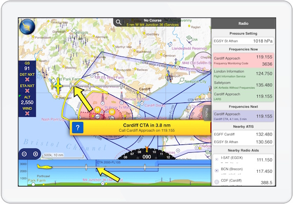
Who you gonna call? Our Radio tab will tell you. Open the tab to see available radio services for your current position and where you'll be flying next. These include flight information services, air traffic control for airspace, nearby ATIS, nearby radio navigation aids, and services offered by your destination airfield. It even shows the pressure setting for the nearest airfield offering a METAR. Outside of the radio tab, simply tap on any airfield to see a list of its frequencies.
If you have a sudden need to divert, you can bring up the Direct To feature. This lists all nearby airfields along with their runways and their location relative to you, and with one touch you can instantly plot a route directly to the destination of your choice.
Approaching your Destination
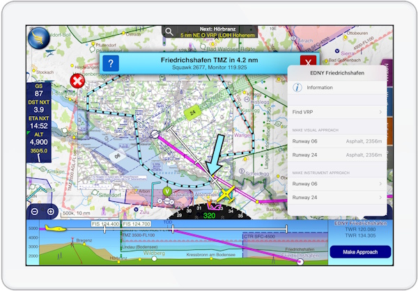
As you get close to your destination, you'll notice extended runway centrelines on the map and a briefing instrument at the bottom right of the screen giving you the frequency to call. Touch that instrument, or one of the extended runway centrelines, and you can nominate a specific visual approach and circuit join, or an instrument approach. In either case you can embed a georeferenced approach plate inside the SkyDemon chart.
A wealth of information is available at your fingertips for your destination. The Airfields tab will quickly show you runway layout, frequencies, elevation, local weather, any applicable NOTAM and available documents from the AIP and third-party publishers. The map will clearly show your position relative to the chosen circuit and join.
After landing, you'll see the airfield ground features clearly mapped, which can be really useful at unfamiliar places with complicated taxiway layouts. Your flight will have been logged automatically, and these logs can be inspected in detail to see exactly where you went, and shared with friends. Our digital logbook service is part-FCL compliant, and if you wish to use it, importing your recent flights is easy.